Business Sectors
Events
Contents
Solutions for detecting GNSS jamming
Preventing the interference of satellite positioning services is key to avoiding accidents
Spoofing and jamming of signals from global navigation satellite system (GNSS) services can impact dynamic positioning (DP) systems and the general navigation of vessels. It can also affect the positioning of autonomous vessels, such as remote survey units.
There have been incidents of GNSS tampering in the Middle East, Black Sea and East Asia, resulting in navigation issues; problems can also occur if automatic identification system (AIS) signals are interfered with, from the satellite or the vessel.
It is the responsibility of both satellite owners and vessel operators to help prevent such services being interrupted.
The European Space Agency (ESA) has contracted Switzerland-headquartered cyber security company CYSEC SA to investigate ways to protect its satellite services for ship positioning and tracking. CYSEC will use its secured servers and satellite communications experience to investigate protection measures for the ESA’s satellite AIS.
From the vessel side, owners need to be able to detect, respond and recover from any cyber attack, whether the onboard IT systems or GNSS positioning.
“Owners should identify vulnerable systems and apply protection before there is an interruption,” says International Marine Contractors Association (IMCA) technical adviser, competence and training, remote systems and ROV Andre Rose.
“To achieve this level of protection we need to be able to verify the satisfactory performance of the operations technology (OT) cyber security system,” says Mr Rose. He suggests this is achieved “by ensuring correct, safe, efficient and reliable operation through software quality engineering and also preventing malicious and non-malicious threats through the cyber security system.”
He says functional testing will help assess a system against known errors or threats. Owners then need ongoing monitoring, assessment and improvements to cyber security to defend against unknown events.
From the vessel side, owners need to be able to detect, respond and recover from any cyberattack, whether it is on the onboard IT systems or GNSS positioning.
Owners should identify vulnerable systems and apply protection before there is an interruption as part of an overall cyber security procedure.
North Sea OSV operator Atlantic Offshore adapted Fleet Secure Endpoint from Inmarsat to protect against ongoing cyber threats to coincide with a Fleet Xpress bandwidth upgrade across its fleet.
This protects ship networks at their vulnerable ‘endpoints’, from a business-critical computer, or operational technology to a crew laptop.
The multi-layered protection scans the network and eliminates malicious encryption, blocks forbidden sites, shuts down malicious connections and runs anti-spyware/anti-phishing software. It only allows trusted endpoints to interact with the network, with new devices labelled rogue until verified. Malware introduced by infected USBs also prompts ‘guardian portal’ intervention.
Jamming detection
To detect an issue with a GNSS signal, vessel crew should be trained in alternative methods of ship positioning for navigation. DP operators should be taught to detect an error and swiftly take action.
In May 2020, Regulus Cyber raised US$4M in funding to help US authorities in the protection of positioning and navigation provided by GPS. Regulus’ Pyramid GNSS software uses machine learning to detect spoofing and defend any GNSS receiver, device, or chipset against it.
Pyramid GNSS uses a combination of patented algorithms to protect against attacks at the firmware, operating system, or application level, including GNSS spoofing. It has wide range of applications, including automotive, mobile, IoT and critical infrastructure and could be used in maritime and offshore.
Focus Telecom has installed GPSdome unit, developed by infiniDome, for cyber protection of the GNSS signals used for atomic clocks at the Israel National Physics Lab.
This will detect interference to GNSS through infiniDome’s Communication Module, which reports any attacks to a cyber security cloud. GPSdome is based on military technologies and principals adapted for commercial use.
Part of the risk from GPS interference stems from an over-reliance on bridge system technology for navigation. To combat this, seafarers should be encouraged to use back-up methods of positioning, such as inertial navigation instruments, dead reckoning and chart radar.
Sonardyne International provides technologies for autonomous vessel positioning and navigation in the event of disruption to a GNSS signal. In a project funded by the UK’s national Defence and Security Accelerator (DASA), Sonardyne International’s Sprint-Nav hybrid inertial navigation instrument was integrated with a Sea-Kit X class unmanned surface vehicle (USV) and tested against local real-time kinematic GPS positioning. This solution adapts technology already used by unmanned underwater vehicles, which operate in GNSS-denied environments. Sea-Kit is working with survey specialist Fugro to develop a range of USVs for offshore applications.
Laser and sonar solutions
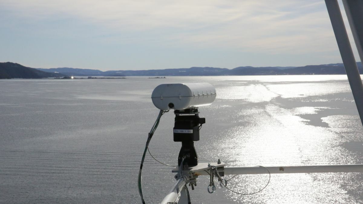
OSVs could also use laser-based detection and ranging (Lidar) devices. This technology is incorporated in the latest laser-based positioning sensors from Guidance Marine for DP operations. It could be used for navigation after a Scandinavian company started testing this in the North Sea.
Ladar Ltd has developed Lidar to augment radar during vessel navigation. A laser pulse scans a specific area and can track specific targets, with over 100 readings per second. It can detect objects in the surface layer up to almost 2 km and to a depth of 10 m. It can detect floating objects, a person, small craft, icebergs or marine mammals, and environmental factors such as waves or pollution.
“The system’s proven capability to detect, characterise, classify and track various surface-layer objects in real time makes it suitable for a wide variety of applications,” says Ladar principal Sverre Dokken. “It overlaps many existing ship radar functions with the added benefits of high-speed operation and no latency,” he adds. This device can be configured to different light bandwidths as required.
“Owners should identify vulnerable systems and apply protection before there is an interruption”
Ladar can incorporate laser diodes together with optical camera, gyros, optional AIS, and radar and sonar feeds to produce a comprehensive analysis of the ocean surface layer ahead of a vessel.
Its data is accessed on a graphical user interface or through a virtual and augmented reality device. Data can be analysed through machine learning to continuously improve detection and classification capabilities.
It can be used for safe re-routing around navigational hazards and for charting of marine plastic pollution, wave spectrum and ocean current observations, mapping of moving sandbanks and uncharted reefs.
Farsounder’s sonar can also be used for improving navigation in shallow waters and congested shipping areas. Its latest device, Argos 1000, can detecting hazards out to 1,000 m, says Farsounder chief executive Cheryl Zimmerman. It is developing more functions for this sonar equipment to further enhance navigation.
“These systems offer three modes that give a varying field of view (FOV). Operators can choose a mode based on the needs and speed of the ship,” she says.
When an OSV is travelling at a higher speed it has 1 km visibility with a 60° FOV.
It can switch to a mid-way mode with 500 m and over 90° FOV.
“If they need to have a high level of situation awareness at low speed, or if they are looking for an anchorage, vessels can switch to 200 m mode and get a 120° FOV,” says Ms Zimmerman.
Farsounder is working to ensure Argos 1000 can be connected to integrated bridge systems to include Argos navigation data into more platforms.
Related to this Story
Women in Maritime Today: Elin Saltkjel says no day working in maritime is dull
Events
Maritime Environmental Protection Webinar Week
Cyber & Vessel Security Webinar Week
The illusion of safety: what we're getting wrong about crews, tech, and fatigue
Responsible Ship Recycling Forum 2025
© 2024 Riviera Maritime Media Ltd.
