Business Sectors
Events
Marine Coatings Webinar Week
Contents
Register to read more articles.
Technology developed for smart waterway navigation
High-frequency radar, automated course and track control systems and type-approved ECDIS provide seafarers with enhanced information for safe navigation
Inland and coastal towage will need new bridge technologies and sensors for smart navigation and semi-autonomous operations. The future of navigation will not replace seafarers but provide greater levels of support and more accurate sensors.
Alphatron Marine, a Japan Radio Co (JRC) affiliate, is introducing smart technologies for navigating in inland waterways and in congested waterways using intelligence and decision-support systems. This recognises people still need to operate and control vessels, but with autonomous navigation devices to avoid accidents and incidents.
Its AlphaRiverTrackPilot is a fully automated course and track control system for the inland shipping segment, allowing a vessel to sail along a predefined line, which is a step towards smart ship navigation. This uses sensors, data and algorithms to autonomously plan and perform navigation tasks, providing navigation assistance, route guidance and voyage planning.
“Relying on autonomous navigation makes it easier for vessels to avoid collisions and other potential hazards, helping to reduce the risk of human error and provides operators with a greater margin of safety,” says Alphatron Marine.
“Autonomous navigation systems are also used to monitor and control the vessel’s performance and position. They help reduce the need for manual labour in the navigation process, freeing up more time for other tasks, such as monitoring and control.”
Along with these bridge systems, accurate sensors with redundancies for safe navigation in all weather conditions will be available.
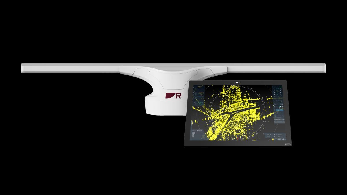
Raymarine has introduced an IMO-compliant solid-state X-band radar for category 2 and 3 vessels up to 10,000 gt, including deepsea towage and offshore vessels, called Pathfinder Radar.
It has higher resolution and detection capabilities than previous radar and complies with IEC 62288 and IEC 62388 standards. Solid-state technology minimises maintenance and enhances longevity for maritime situational awareness.
Pathfinder is driven by a fanless, 1.8-m, low-profile open array antenna, and it has increased long-range resolution using CHIRP pulse compression and beam sharpening technology and multiple target detection and tracking. It is available with console mounts, deck stands, or desktop mounts for easy retrofitting. The graphical displays are available in 41 cm or 48 cm for CAT 3 vessels, or 56 cm or 61 cm for CAT 2 vessels. Raymarine’s HydroTough nano-coating repels water and oil contaminants and offers high definition and visibility in bright sunlight.
Bridge technology also needs to include high-frequency radar to back up existing Inertial Measurement Units (IMUs) and input from the Global Navigation Satellite System (GNSS), which is vulnerable to interference, jamming or spoofing.
Halma’s Navtech Radar product manager Sam Wood says when a GNSS system is faced with an outage, the IMU, X-band radars, cameras and Lidars would still fall short in providing accurate vessel positioning in congested waterways.
“Though the combination of GNSS and IMU offers an initial foundation, there are weaknesses with both technologies,” he explains. “GNSS’s accuracy typically ranges from 5-10 m, falling short in situations where precise positioning is crucial, such as when passing under bridges, docking or navigating through locks.”
While corrections can improve accuracies to 3-5 cm, there are limitations due to challenges from signal obstructions in urban environments, satellite visibility issues in remote areas and potential latency in delivering real-time corrections, “all of which can have an impact on the overall effectiveness of precision positioning for maritime activities,” says Mr Wood.
“While the addition of IMUs improves robustness, providing valuable data for navigation, their susceptibility to drift poses a significant challenge when GNSS signals are unavailable or compromised.” This could lead to a drift of 15 m in just 60 seconds and a gradual accumulation of errors, leading to course deviations.
Other traditional sensors have their own limitations when it comes to centimetre-level positioning, range and robustness in adverse weather. “X-band radar struggles to provide the required resolution for precise navigation,” says Mr Wood. “Cameras do not have the ranging information for accurate positioning, stereo cameras have a small operating window for optimum ranging and Lidar does not have the range nor robustness for reliable detection in the maritime environment.”
He says the solution for cm-level positioning congested waterways is using high-frequency radar, such as emerging W-band radar which has the resolution of Lidar, while retaining the range and robustness. High-frequency radar operates in the mm-wave spectrum, to deliver precision and detect small objects with clarity in 360° around a vessel in all weather and light conditions.
“The resulting detailed detections from small navigation buoys, jetty pylons and harbour wall details enables features to be clear describing the location, resulting in cm-level positioning in any weather condition and the ability to run significant distances off the mapped routes,” says Mr Wood.
Chart systems
ECDIS and other electronic navigational chart systems are increasingly important for safe coastal and waterway navigation, with more information overlays and accurate bathymetry coming.
From 1 January 2024, all new ECDIS installations on Europe-flagged vessels are required to meet the International Electrotechnical Commission (IEC) standard IEC 62288 Edition 3 covering the presentation of navigation-related information. New ECDIS products need class type-approval verifying they meet these standards.
In December 2023, ChartWorld gained DNV type-approval for its eGlobe G2 ECDIS ensuring the software meets IEC 62288 with new standard symbols, AIS-related colours and enhanced handling of safety-related messages.
Chartworld director for maritime solutions Ralf Lehnert says eGlobe G2 ECDIS was one of the first systems to comply with the new standard.
“It was a challenge to achieve this approval in time, as the implementation period granted by the IEC was relatively short. We were prepared and we booked an approval slot early enough with DNV to present and demonstrate the updated functionality.” Chartworld is developing interactive eGlobe onboard familiarisation training for introduction in Q2 2024.
Chartworld has also unveiled an information overlay (CIO+) data service for Tokyo Keiki EC9000 and EC8100/8600 models. This sources information from the UK Hydrographic Office’s notices to mariners and temporary and preliminary notices from China, India, Colombia, and Denmark, plus navigational warnings from each NavArea co-ordinator and warnings from more than 150 coastal and local authorities.
ChartWorld has also updated its MyRA 1.8 automatic voyage planning tool with improvements and new features such as the ability to avoid or minimise navigating in pre-defined areas, expanded ECDIS compatibilities and automatic route creation capabilities.
It can automatically convert route orders to voyage plans, which can be adjusted by crew to reflect onboard vessel and voyage conditions.
Furuno has introduced five different sizes of multi-function displays in its NavNet TZtouchXL series with updated user interfaces for navigating using raster or vector charts, satellite photos and bathymetric data. Users can create their own custom objects or make updates to charted objects such as buoys.
BathyVision provides configurable depth contour lines with resolution to 7.6 cm to be overlaid on charts. AI Routing will plan routes considering vessel draught and navigation obstacles. When connected to a DRS Radar, two new safety features are unlocked - Risk Visualizer for alerts and AI Avoidance Route to plot safe routes around hazards, which can be sent to a Furuno NAVpilot series autopilot.
In brief
Digital Yacht introduced Nomad 2, aportable AIS transponder for delivery crews and pilots to transmit vessel identity and position information and receive local AIS traffic data.
Miros has added a feature to its real-time ocean data measuring devices for forecasting sea conditions.
The 27th International Tug & Salvage Convention, Exhibition & Awards will be held in association with Caterpillar in Dubai, UAE, 21-23 May 2024. Use this link for more details of this industry event and the associated social and networking opportunities; and this link to book your ticket for the exhibition, social gatherings and awards night.
Related to this Story
Events
Marine Coatings Webinar Week
Maritime Environmental Protection Webinar Week
Ship Recycling Webinar Week
© 2024 Riviera Maritime Media Ltd.
