Business Sectors
Contents
Tug wheelhouse technology for better navigation
New gyro compasses and radar have solid-state technology with fewer moving components, while thermal cameras and ECDIS provide tug masters with greater situational awareness
Tugs built in the future will come with a new generation of gyro compasses, ECDIS, radar and thermal cameras. These have higher functionality and new features for improved situational awareness, less maintenance and information overlay.
In Q1 2020, Furuno Electric introduced magnetron-free radar and chart radar with solid-state technology for both X-band and S-band configuration in the FAR-NXT 2xx8 and FAR-3xxx series.
Solid-state radar uses electronic components to generate microwave pulses and therefore requires much less power than magnetron radar. This technology does not wear out or require maintenance, significantly reducing operating costs. There is no pre-heating making the start-up time much faster than with a magnetron.
Northrop Grumman Sperry Marine has introduced its Navigat 2500 and 3500 fibre-optic gyro compasses. These solid-state units offer maintenance-free operation and superior heading measurement in all kinds of dynamic conditions, according to the company. They are compatible with Sperry Marine’s CompassNet networked heading management system.
As solid-state units, Sperry Marine managing director James Collett says these gyro compasses are robust and reliable technology because they have no moving parts.
“It is more important than ever to keep a course and have immediate access to information that could affect vessel safety,” says Mr Collett. Its importance for tugs is in their transit voyages between ports and during deepsea towage assignments.
These gyro compasses come with simplified cabling, rapid installation and increased redundancy. Sperry Marine also signed a global distribution agreement with system integrator Radio Holland covering CompassNet heading management systems, Navigat 2500 and 3500 fibre-optic gyro compasses and Navigat 100 and 200 spinning mass gyros.
Raytheon Anschütz introduced its new Standard 22 NX gyro compass in March, offering additional interfaces and integrated sensors.
Standard 22 NX has more interfacing flexibility as it connects to additional heading receivers or has a direct connection to a Bridge Alert Management system.
“The new interface capabilities will simplify and shorten system integration, installation and commissioning,” says Raytheon Anschütz product manager for gyro compasses Olav Denker. “This contributes to overall cost efficiency and an even more positive cost-lifetime performance ratio.”
There are additional interfaces to National Marine Electronics Association (NMEA)-standard equipment for extra heading and positioning sensors. Interfaces are configured by selecting NMEA telegrams, baud and update rates.
Standard 22 NX enables the direct connection of rate-of-turn indicators to the compass system. “This means less separate hardware and less installation efforts are required compared to conventional systems with rate-of-turn requirements,” says Mr Denker.
Enhanced situational awareness
The latest series of thermal cameras can improve situational awareness for tug masters, providing safer navigation in poor visibility, and easier manoeuvring at close-quarters and when docking.
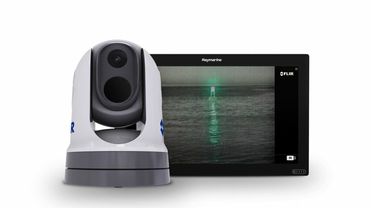
FLIR has introduced its M300 series of cameras to provide additional information to tug masters. High definition colour video from these cameras can be integrated into a navigation package on tugs.
There are five models in the M300 series. These feature rugged and robust new pan and tilt housings and an integrated attitude heading reference system, providing a steady view in rough seas. The flagship dual-sensor M364C and M364C LR models integrate thermal and visible imagery for sharper detail and colour, making it easier to distinguish navigation marks and running lights, identify buoys, vessels and other targets at night.
These cameras feature FLIR MSX imaging technology, which extracts edges and borders from the HD-visible camera and blends these elements with the thermal image, giving operators improved visual recognition of distant objects.
Cameras provide more detail than radar to fill the close-quarters gap for detailed imagery of tug surroundings, such as the heat signature from another vessel’s engine or a person in the water.
ECDIS and ENCs
Tugs increasingly have ECDIS on board for e-navigation between ports or during oceangoing towage. Tug Technology & Business has used ECDIS on a tug in the River Thames, UK, for increased situational awareness during manoeuvres.
Wärtsilä’s latest connected ECDIS, Translink, gained DNV GL type-approval and cyber security certification by the International Electrotechnical Commission (IEC). These certificates validate Translink has the key components for secure operations. It has IEC 61162-460, a recognised standard for cyber security for bridge and navigation systems and for advanced voyage planning and execution.
“Digitalisation offers more efficient and better ways of operating and designing vessel equipment, such as integrated voyage planning including the remote update of ECDIS charts,” says DNV GL group leader for cyber safety and security, Jarle Coll Blomhoff.
“With a third-party cyber verification, vessel owners can take advantage of new technologies with assurance it follows best practice cyber security design,” he says.
ECDIS uses electronic navigational charts (ENCs) produced by hydrographic offices worldwide, collated, cross-checked and distributed to tugs globally.
Navico produces ENCs through its C-Map products and distribution network. One of the latest to join this network was ChartWorld International, which become a distributor of C-Map’s ENCs in S-63 format in March. Data can be provided as C-Map areas, covering local regions or larger C-Map zones and global coverage in one dataset. C-Map charts are updated quarterly by new chart editions and notices to mariners issued by national hydrographic offices.
ChartWorld also introduced version 1.2 of its voyage planning platform MyRoute Appraisal
(MyRA). This considers different stages of a passage and applies voyage and safety parameters for the route calculation and safety checks. These voyage plans can be loaded on to ECDIS and have automatically calculated safety corridors.
MyRA 1.2 subdivides the voyage plan into four segments – berthing, confined waters, coastal waters and open sea – each with different safety parameters and supported by bathymetry.
ChartWorld has improved accuracy for initial route setting and the route-check.
GNS has introduced functionality to ECDIS using C-Map charts or Admiralty Vector Chart Service (AVCS) Online from the UK Hydrographic Office (UKHO).
Voyager Fleet Insight (VFI) web service enables remote monitoring and management of ships from shore. It provides data to remote-working teams in tug management departments. VFI Plus has live tug positioning on ENCs and overlays of current and forecast weather conditions.
In March, UKHO authorised GNS and Bogerd Martin as its first distributors of AVCS Online. Bogerd Martin integrated this into its Chart Track Ship Manager. AVCS Online gives shore-based users and fleet planning team access to more than 15,000 ENCs to support vessel tracking, voyage planning and to use in emergency incidents. These ENCs are already available to navigation teams on tugs.
Class certification and contract awards
Japan Radio Co (JRC)/Alphatron gained certification from Russian Maritime Register of Shipping (RS) for a range of bridge systems, enabling these to be installed on tugs and icebreakers built for Arctic conditions.
This certification covers GPS compasses JLR-21 and JLR-31, echosounder JFE-380 and a range of doppler speed logs. RS also certified JRC’s JMA-3300 radar, different types of black box radar, Weatherfax JAX-9B, Navtex, safety satellite communications and different kinds of medium-frequency and high-frequency radio equipment. This certification enables JRC to distribute its bridge equipment in the Russian Federation and provide servicing in ports and offshore bases.
Navico has secured a five-year agreement to provide C-Map charts to the United States Coast Guard’s (USCG) small boat product line. This sees Navico supplying cartography cards to 300 different USCG stations across the US, twice a year. This team manages around 1,800 boats in 26 different classes with Furuno and Raymarine navigation systems.
Related to this Story
Events
TUGTECHNOLOGY '25
Reefer container market outlook: Trade disruption, demand shifts & the role of technology
Asia Maritime & Offshore Webinar Week 2025
Marine Lubricants Webinar Week 2025
© 2024 Riviera Maritime Media Ltd.

