Business Sectors
Events
Offshore Wind Webinar Week
Contents
New DP system combats spoofing and interference
The Sonardyne SPRINT-Nav DP reference system can provide accurate and reliable positioning without a GNSS signal, making it well suited for shallow-water operations
Offshore support vessels and drilling rigs use dynamic positioning (DP) systems to maintain precise positioning and heading. But GNSS signals that provide reference information to DP systems face increasing interference in conflict zones, shallow-water areas, offshore windfarm sites and nearshore operations, according to Duncan Rigg, Sonardyne business development manager, vessel systems.
The Sonardyne executive said there are “lots of issues at the moment globally with relying on GNSS systems”. Spoofing, jamming and blocking in conflict zones in the Middle East and near Ukraine and Russia are not uncommon. In his presentation at Offshore Support Journal Conference, Asia in Singapore, Mr Rigg showed a heat map of the southern Baltic illustrating how intermittent GNSS signals impact marine operations on a regular basis. Other factors that can distort or block GNSS signals are atmospheric conditions, physical obstructions, inference from other radio frequencies and a receiver’s limitations.
Mr Rigg said several alternatives to GNSS are available to DP operators. One alternative is laser-based systems, which he said were “absolutely fantastic, widely adopted, relatively easy to install,” but require an asset to use as a reference point.
“There are lots of issues globally with relying on GNSS systems”
Another solution is microwave radio-based systems which create a line-of-sight communication link between a fixed reference station and a vessel to determine range, bearing and independent satellite signals. These have “fantastic range, are relatively easy to install,” he said, “but require something to put the receiver on.”
Taut wire systems provide a reliable and consistent means of measuring a vessel’s position for dynamic positioning. “However, there is a limitation with them, particularly in areas where there are lots of assets on the seabed. You don’t necessarily want something like a heavy concrete weight being deployed that could be dragged across and damage these assets,” said Mr Rigg.
Hydroacoustic systems can be complicated, have a limited operational footprint, and require the deployment of a transponder on the seabed, explained Mr Rigg. “When you are working in shallow water, you might be able to move only a few 100 meters away from the transponder,” he said.
Shallow-water solution
Privately held, UK-based Sonardyne, which has been building underwater positioning and navigation systems predominately for the DP market for more than 50 years, set out a few years ago to develop a solution.
“We have been building inertial navigation systems for about 15 years that are incredibly accurate for a short period of time. And by incredibly accurate, I mean millimeters over the course of a minute. But they will start to drift quickly. So, you need to constrain that drift,” explained Mr Rigg.
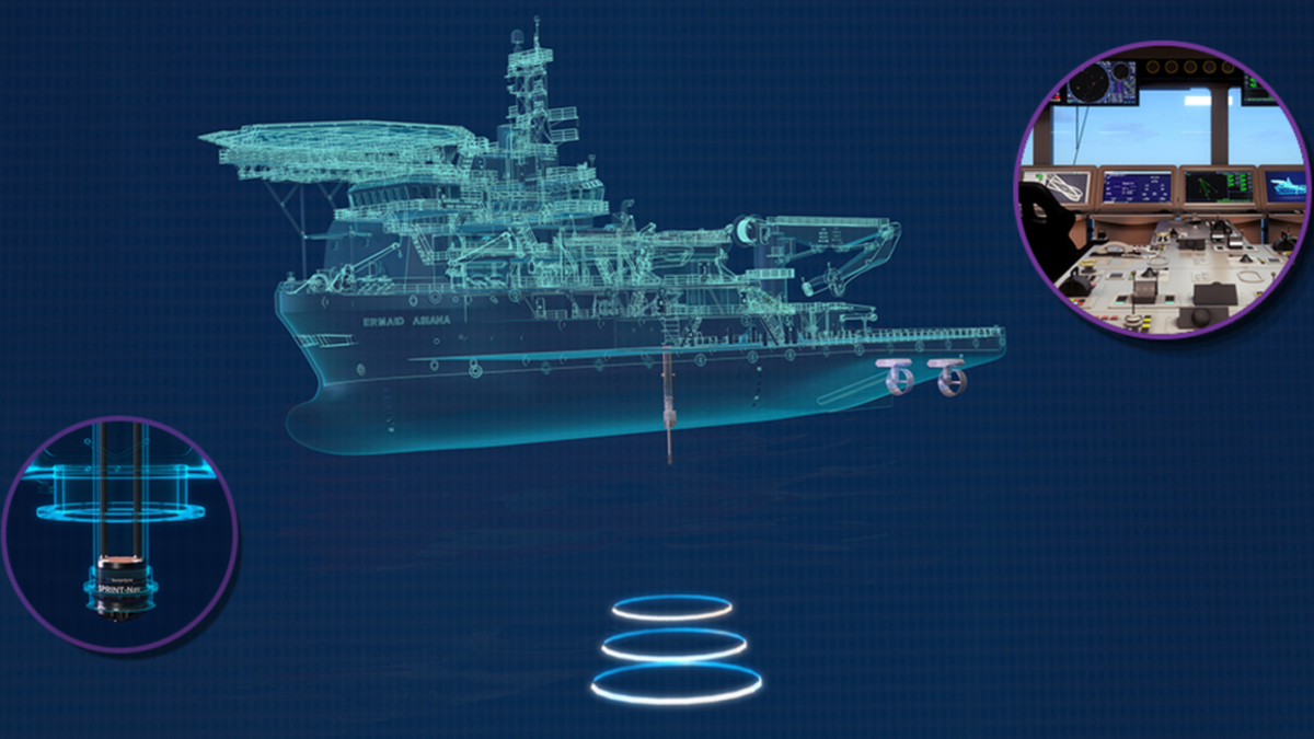
To overcome the problem of drift, Sonardyne’s newly developed SPRINT-NAV DP uses vessel speed and a Doppler velocity log (DVL) to provide that information to the INS.
The shallow-water DP reference system integrates high-grade inertial navigation with DVL technology in a single, pre-calibrated unit.
One driver in its development was an increasing demand from offshore windfarm vessel operators for shallow-water DP operations. Mr Rigg explained that one of the issues for DP-2- and DP-3-class vessels is to maintain compliance when working in shallow water.
Prior to its commercial launch, the system underwent extensive trials and validation tests to ensure it maintains the mandatory class requirements as an alternative position reference into a vessel’s DP system.
SPRINT-Nav DP can provide accurate and reliable positioning without the need for a GNSS signal, making it well suited for a wide range of shallow-water operations, including offshore renewable and nearshore work.
The system uses DVL bottom-lock technology and does not require the deployment of sensors or other equipment - the seabed itself is used as the positioning reference.
A video in Mr Rigg’s presentation explained that the new system can be used in shallow water down to 225 meters, integrating “seamlessly with the vessel’s dynamic positioning system. SPRINT Nav DP negates GNSS outages during operations spoofing and jamming, making it the perfect solution for applications where GPS is unreliable.”
Early trials
Real-world applications have shown the system’s effectiveness. The first trial of SPRINT-NAV DP took place in 2019 when it was deployed on a DP-2-class multipurpose support vessel operating in water of about 10 m in the Arabian Gulf. It offered ADNOC a viable solution where taut wire, acoustics and laser-based systems were not options.
The system was also tested on Ocean Vantage conducting geotechnical drilling operations in the southern Baltic Sea. “If you are familiar with acoustic positioning systems, you know their range can be limited by how noisy a vessel is or by aerated water. So, when the opportunity came to install the system on a geotechnical vessel, we jumped at the chance,” said Mr Rigg.
By Mr Rigg’s account, SPRINT-Nav DP passed the trial with high marks. He observed: “We achieved a difference of less than three meters over a three-day period from GNSS. That’s just the unit measuring and calculating its position. We didn’t get a single drop out, a single rejection in any of the data over the three-day period, and to the point where our engineers thought it was all completely simulated data. They couldn’t quite believe how clean it was, but it was extremely stable.”
A trial was conducted for a UK Ministry of Defence-funded project that assessed the, accuracy of using the system on a Seacat USV without the benefit of GNSS, while another test on a Spliethoff DP-2-class heavy-lift vessel validated its use for DP operations.
“But it just proves as a concept that you don’t have to have GNSS to be able to operate in these types of scenarios,” said Mr Rigg.
“We are starting to gain market traction. There is a lot of interest, especially with everything that’s going on with GNSS problems” he concluded.
Related to this Story
Events
Offshore Wind Webinar Week
Maritime Decarbonisation, Europe: Conference, Awards & Exhibition 2025
Offshore Support Journal Conference, Americas 2025
© 2024 Riviera Maritime Media Ltd.
